© SeeMeribel.com

Maps of Meribel
Download the essential Meribel maps and plans
We hope this selection of piste and lift maps, street maps, and activity area maps for Meribel will help you find your way around so you can make the most of this great part of the world.
Méribel is situated in the heart of the Three Valleys and, whilst the principle town is of the same name, Méribel is often used in reference to the whole valley. It is, however, made up of several distinct and charming villages including Mottaret, Les Allues and Méribel Village, each with its own distinct ambiance.
Méribel is situated between 1,450m and 1,700m, with the separate satellite village Méribel-Mottaret sitting higher at 1,700-1,800m. Lower in the valley are several traditional villages, with Les Allues and Raffort linked to the main lift system by gondola.
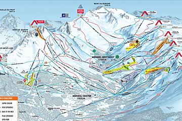
Piste maps
Lifts marked on the piste map using straight black lines are of four types: button tow/drag lift, chairlift, télécabine and télephérique. They have the corresponding abbreviations:
- TK - téléski (drag lift)
- TS - télésiege (chairlift)
- TC - télécabine (gondola)
- TPH - téléphérique (cable car)
Anything prefixed/suffixed with “Express” means a six-person, fast chairlift.
Town maps
| Méribel Town Maps |
|---|
| Méribel Town Map |
| Brides les Bains Town Map |
Winter walking / trail maps
Cross-country skiing maps
| Méribel Cross-Country Skiing Maps |
|---|
| Méribel & Courchevel Cross-Country Skiing Map |
| Belleville Valley Nordic Trails & Skiing Map |
Hiking & walking maps
| Méribel Hiking & Walking Maps |
|---|
| Meribel Hiking Trails Map |
| 3 Valleys Hiking Trails Map |
| Courchevel Hiking Trails Map |
| Belleville Valley Hiking Trails Map |
Mountain bike trail maps
| Méribel Mountain Bike Trail Maps |
|---|
| Meribel Mountain Bike Trail Map |
| 3 Valleys Mountain Bike Trail Map |
| Courchevel Mountain Bike Trail Map |
| Belleville Valley Mountain Bike Trail Map |