© Merinet

Hiking Routes in Meribel
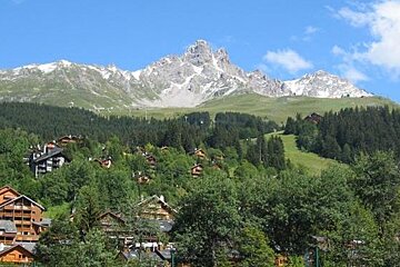
Meribel has a range of hiking routes, some are more challenging than others, with hikes at the base of glaciers and some easier mountain hikes allowing you to explore the Alps and the Meribel Valley. From the high altitude hikes you can witness the breathtaking scenery and picturesque views that the mountains have to offer.
There are various mountain guides who will lead you on your hike or you can choose to tackle the trail or route on your own but just make sure you are fully equipped, prepared and have all the full details before setting off.
Below are a selection of some of the suggested hiking routes in Meribel. There are many more to choose from, so pick up a guide or map from a magasin or information point to explore some of the other routes.
Hike 1:
Starting Point: Meribel Mottaret - top of the Pas Du Lac 2
This high altitude hike is rated as a difficult route, covering varying terrain. It can be found on the map marked as route 27. Starting from the top of Pas du Lac 2 bubble lift you can follow the trail, from this altitude you can enjoy the beautiful scenery of the valley below and the mountains in the surrounding area and distance. Keeping on the trail towards Col de Fruit where you can then start the descent downwards towards Lac du Tueda. Here you can explore the lake and Vanoise Nature Reserve, with unspoilt wildlife and mountains. You can either walk back to Meribel Mottaret or hop on a bus back to Meribel. Alternatively you can do the route the other way, taking the lift down into Meribel Mottaret at the end, challenging yourself with the uphill route.
Hike 2:
Starting point: Lac Tueda
This challenging hike is rated as 'very difficult', so make sure you are fully prepared before heading off. Labelled on the map as Route 26. Starting from Lac Tueda which you can get to via bus and a short 10 minute walk or, there is a large free car park close by. Once here you want to walk to the far end of the lake along the flat trail, once you reach the far side you want to take the trail that heads up the mountain towards Les Mures des Rouges and Plan des Mains. Walking through the tree lined and meadow lined trail you can take in the beautiful alpine summer scenery. At Plan des Mains you want to keep following the trail to Côte Brune. Here there will be a fork in the trail where you will want to take a left, after a short walk upwards there will be another fork in the trail where you will turn left. Follow the trail as it heads onwards and winds around the mountains. Heading towards Lacs du Borgne, the challenging trail will take you high up to Mont Vallon. There is a viewing map and point from here where you can see the surrounding mountains and valley. To get back down the mountain you can follow the route you took up or take the easier route marked 28 on the map.